
Winter brings with it a range of hefty responsibilities for public administrations, such as de-icing and snow removal, which tend to draw considerable attention and scrutiny from the public and from governments themselves. These operations must not only be swift, but they also require close quality control to ensure governments are able to respond to inquiries, assess the validity of complaints and make any necessary corrections.
And that’s where choosing the right technology becomes essential. The solutions available include field data collection tools such as ArcGIS Tracker, Collector and Survey123, a map‑sharing application like ArcGIS Online, and a platform for presenting results like ArcGIS Dashboards. Geomaticians like City of Montréal’s Tahir Tamba see in these solutions a perfect opportunity to leverage their expertise and to get returns on investment in ArcGIS and FME.
Making public roads safer
The success of projects to improve the safety of public roads relies on the ability of operation supervisors to get up-to-date information on the quality of snow removal and de-icing operations. This helps them ensure that the work is evenly effective across all sectors and that public roads remain safe, even after snow-loading operations. They also need to have access to data and stats, both for the current storm and for storms over time, so they can identify trends and improve service quality.
Where Esri applications come in
Forepeople can use Survey123 forms and ArcGIS Collector on tablets to track snow removal progress by sector (e.g., sector X shows snow removal at 90% and de-icing at 75%). Inspection reports are based on strategic sampling points chosen for each sector and assigned to inspectors at the beginning of each incident (storm).
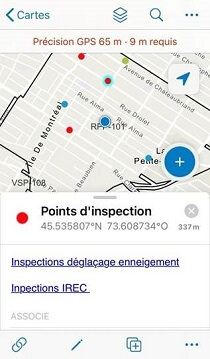
With so many different inspection points for the same theme, it is difficult to get a comprehensive view that is easy to interpret. This was solved by dating the results and then adding a polygon for each snow removal sector in a feature layer in ArcGIS Online. A spatial join was created between inspection points and sector polygons, statistical calculations were added, and voilà! The supervisors now had a dashboard that featured a map with a comprehensive view that was both clear and representative of the progress on the field.
What FME brings to the table
Without some FME magic, certain stages of the process would still have to be done by hand. For instance, processing inspection results in ArcGIS Online, adding data fields, manipulating intermediate tables, and compiling statistics by sector and publishing them on ArcGIS Online are all time-consuming operations. Altogether, they can add a few hours to each update and, because each storm requires several updates, they could run up to almost a whole day’s worth of work during snow‑loading and de-icing operations.
FME lets you put together a single workspace for all of the steps above. City of Montréal geomatician Tahir Tamba, for example, feeds his operation dates into his workspace a single time, and FME automates the rest. This is a 30-second operation that could save you days of work per incident.
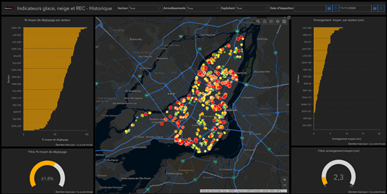
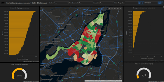
ArcGIS Dashboards results speak for themselves
If you choose to take on the process we described before without FME, your operation supervisors and managers can use ArcGIS Online and some preconfigured ArcGIS dashboards to see the qualitative results of snow removal operations and your de-icing indicator with up‑to‑date information. It’s a good start.
However, if you use ArcGIS Dashboards to configure your field inspection reports, FME’s automation process gives you an exhaustive, real-time (or almost real-time) picture of the operations by snow removal sector, as well as an end‑of‑season compilation based on the sum of all reports from the past winter. With ArcGIS Dashboards, supervisors and managers can use this compilation to get a better idea of the operations for past storms. The information (compiled real-time and previous data) contained on this dashboard is a powerful decision support tool that can be leveraged to improve service quality.
Looking to get better returns on your investment in ArcGIS products?