
Ideally, every city should have a solution for tracking work and gathering information on its assets in order to better manage its territory and gain better knowledge of its infrastructure. But to encourage buy-in and deliver real benefits, this solution needs to be designed so that employees and subcontractors can enter and share information in a way that is customized, simple and secure.
One way it could be used is when a subcontractor needs to mark the area they are working in on a map. Another is a public works employee conducting inspections to enter pictures of a faulty fire hydrant with a description, or to confirm that they have performed maintenance tasks, such as flooding an outdoor ice rink.
Possible solutions
If you are used to Esri technology, you should definitely consider solutions such as Collector for ArcGIS and ArcGIS Survey123. You can even use FME to add post-processing and automate connections to other systems. Of course, if you are looking to implement an app for a large number of users, licensing fees could be a deterrent.
From a cost savings perspective, one option you should look at is FME Server Workspace Apps, offered by Safe Software, as an interesting solution that won’t break the bank. A downside is that it only offers fairly generic features, which means it takes more work to customize it for users who aren’t familiar with the technology.
A web portal powered by FME Server
As part of a project assigned by the geomatics team of the City of Terrebonne, we focused on developing a web portal around FME Server, as we wanted to build a solution that was reasonably priced and without any user fees or recurring annual costs. This portal needed to have a user-friendly interface for employees in the field who aren’t necessarily tech savvy. The solution also had to be portable and compatible with a variety of platforms, such as tablets, cellphones and laptops. From an internal administration standpoint, the solution could rely on FME Server’s monitoring capabilities and allow GIS experts to automatically integrate FME Workspaces.
As many municipal organizations use a Microsoft environment, we developed the web portal using ASP.NET for the programming language. The portal communicates with the FME server using its REST API and was designed to use the permissions of the existing FME server. When it comes to security, the web portal has open access, but is securely connected to FME Server from inside a firewall.
Users, whether city employees or external contractors, can sign-in to the portal through a simple log-in page. Once the user has been authenticated, they will be able to see only the fields required for their work. The FME Server’s REST API handles access to simplify management of user accounts, an important step for giving the right people access to the right information!
Making it easier to publish Workspaces on the portal
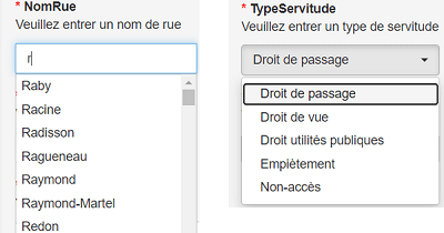
The different parameters published using FME Workspaces are managed and displayed in the web portal’s interface with traditional web components such as drop-down menus and calendars, as well as features such as drag-and-drop uploads. Users enter information into mandatory or optional fields, with field defaults to make things easier in certain cases.
All of the components were developed using Bootstrap to streamline display across multiple platforms. FME Workspaces can also integrate instructions in case a user enters information in the wrong format or forgets a mandatory field.
For the sake of efficiency, the solution allows a list to be displayed without manually configuring all of the elements in the published parameter, such as with a list of street names or multiple types of assets that must be inspected. To accomplish this, we link the lists to the content of a database table. This strategy lets the GIS specialist use a generic configuration allowing for the choice of any field from a database table to pair it with a published parameter.
The same principle also applies to value domains. You just pair the field name with the published parameter so the list can be created without errors and the user can enter data more quickly.
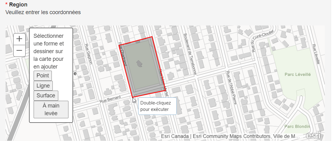
Need a map?
Although there are times when using a map might complicate data entry, at other times users may need to draw shapes on a map, for example to mark a work area or the location of burst pipes. In these specific cases, the app can integrate an ArcGIS public map.
A simple, flexible and affordable solution
To wrap up, there are two main benefits of developing a customized web portal connected to FME Server technology for collecting and processing field data.
The cost of purchasing the solution is fairly reasonable overall, with no recurring annual licensing fees or use costs associated with a large number of users. Additionally, it is easy to adapt the portal to your needs, as additional features can be tacked on using automated connections to the new FME Workspaces.
The solution’s simplicity will also save a great deal of time in managing the portal with FME Server’s proven features and in using it in the field, thanks to the customized interface with integrated operating instructions.
If you already have FME Server or plan to purchase it and have the expertise to process data with FME, there is a whole other world of possibility out there!
Want to automate the collection and processing of your field data?