
The City of Greater Sudbury, situated on the Canadian Shield in the Great Lakes Basin, is a world class mining center. With 3,627 square kilometers in area, it is the geographically largest municipality in Ontario and second largest in Canada. In 2018, Greater Sudbury was home to approximately 166,000 people. Among other values, the City encourages innovation, continuous improvement and creativity. As such, the Data and Geospatial Services Department was recently created to provide focus and enable the City to take advantage of geomatics and business intelligence (BI).
THE CHALLENGE
In a 2019 report, the City’s auditor issued a recommendation that the City monitor and record road patrol activities on network maintenance so that the administration could respond more efficiently to resident claims (see image below for a list of the kinds of deficiencies reported). The city both explored and received off the shelf offerings for specialized software for managing road patrols that could be used for the data collection process.
At first glance, that option might look interesting. With it also came direct acquisition costs, as well as indirect integration and maintenance costs. Driven by the City’s values of innovation and creativity, the Data and Geospatial Services Department set off to propose a less expensive solution that could maximize the investment already made in existing solutions.
The project also had to strategically consider change management concerns, to help improve both the transition and adoption rate for the Public Works team during the project.
THE SOLUTION
From the outset, it was decided that the project would be broken down into five phases, so that users and managers could gradually digest and adopt the changes. The technology chosen was the ArcGIS platform, which feeds many of the City’s business systems, and the FME data integration platform.
The first phase was to configure and deploy ArcGIS QuickCapture. This app, part of the ArcGIS suite, was created specifically for helping users such as patrol teams collect data on deficiencies from a moving vehicle. It works with voice control, so you don’t even need to have your device in your hands, and it connects directly with ArcGIS Online feature layers.
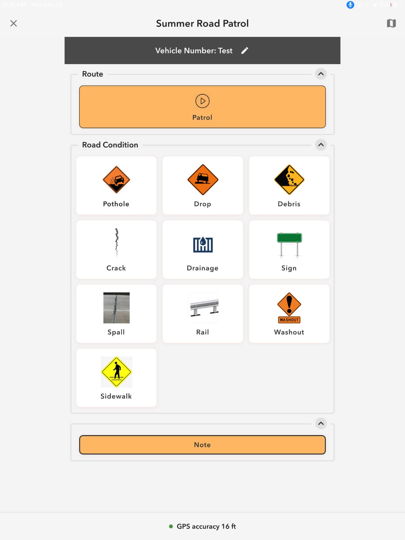
Screenshot of QuickCapture configuration for summer road patrol
The FME data integration platform, which the City was already using, entered the picture as early as the second phase of the project. The Data and Geospatial team developed an FME workspace that scanned all ArcGIS Online layers every evening to compile deficiencies observed during the day and sent a report by email. This step was crucial in terms of change management, since it made information that was available in the app even easier to access—it gave forepersons the option to just look at the Excel file they received every day rather than logging into a GIS app.
In the third phase, a dashboard was created that gave managers a quick overview of the roads that met, or didn’t meet, the Minimum Maintenance Standards (MMS) under regulations 239/02. A new FME workspace was created to automatically feed ArcGIS Dashboards from the data collected from quick capture patrols. It didn’t take long for managers to appreciate the dashboard as a powerful decision support tool, including for swiftly deploying teams to non-compliant areas.
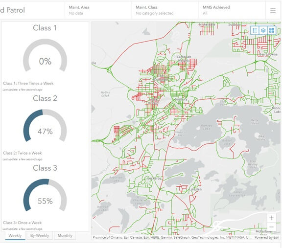
Screenshot of dashboard including a global note and a visual of deficient segments
The fourth phase was necessary to enable the risk management department to quickly obtain accurate information for litigation cases and claims. The Data and Geospatial team developed an ArcGIS Survey123 form that lets users select a geographic area and a time period. Each time a form is filled out, it triggers a webhook, which then enables an FME Server automation. The automation then triggers a workspace that retrieves the information required from the database, turns it into an Excel file and emails it to the requester.
The fifth phase is especially interesting. It automated the creation of work orders in Cityworks, so every time a field team reports a deficiency, ArcGIS QuickCapture triggers an FME Server webhook, which launches an FME workspace that determines the type of deficiency, matches it with one of the repair activities used in Cityworks, and sends a request back to create the work order. This newly automated process spares the City a great number of paper reports and makes it possible for Public Works managers to associate each deficiency to a repair intervention.
THE VALUE PROVIDED
What started out as a project to implement a solution for monitoring and recording road patrol activities in order to better respond to claims received by the City has turned into a push to completely automate all associated activities.
Several of the organization’s departments are the better for it, too. The Public Works team is the greatest beneficiary: this improved and automated process has replaced 6,000 documents that had to be generated and printed before and saved 980 person/hours per year. It also gives their managers nearly real-time access to more accurate information, allowing them to optimize decisions such as the deployment of field teams.
Meanwhile, the City’s risk department has prompt access to the accurate information they need to handle claims more quickly and provide residents with satisfactory service. Also, the information technology department doesn’t have to purchase and maintain yet another application. In addition, FME Server’s no-code features have made it possible to avoid the development of scheduled tasks including complex monitoring options in a near real-time context.
A crucial part of the project was the iterative deployment approach, which ensured full buy-in from all users. It also made it possible to receive quite a bit of user input, which was used to better define the requirements of each subsequent phase. The consensus is clear: no one would want to go back to the way things were done before, and mobile devices will be instrumental in bringing in further improvements in the near future.
The FME suite has been transformational for the City of Greater Sudbury. The flexibility and interoperability it grants us between our core business systems allow our staff to provide managed, organized solutions in record time. Consortech experts have helped us achieve some our immediate goals with the tools-set and have proven to be extremely knowledgeable in the space. We look forward to working with them on future projects.