
Toronto, the capital of the province of Ontario and the largest city in Canada is a dynamic metropolis where the urban planning division plays an important role in helping to build the future of the city by managing its growth and its physical form.
The division also reviews and processes development approval applications from a community planning and an urban design perspective. City Planning staff gather public input and conduct research to develop and review plans, regulations and projects that protect and enhance the urban environment. Among other things, it provides support and advice to City Council to help ensure that the city’s growth contributes to the kind of communities and neighborhoods Torontonians want.
THE CHALLENGE
The Graphics & Visualization team within City Planning decided to build an automation tool capable of creating report maps connected to the development review process for community council. This proposal aligns to the City’s Strategic priority of “Modernization”, as well as technology innovation and paperless transaction.
The production of this report, which accounts for approximately 60% of the group’s workload, consists of manually creating maps using the ArcMap application. This repetitive task prevents the group’s analysts from performing higher value-added tasks such as urban design studies, evidence graphics and 3D modeling. For this reason, Valen Lau, the team’s supervisor contacted Consortech to help him achieve its modernization goal with an automation project.
HOW WE HELPED
To move this project ahead, Valen and the Consortech’s consultant decided to use FME for configuration, cartographic design, workflow and file management. The trigger that enabled the project to be carried out is when the ability to output as a PDF writer was introduced in FME. This new feature allows to read a variety of different formats to produce PDF maps. In this case, information such as key map, location map, official plan land use, zoning By-laws and former zoning By-laws have been included in the report. (see report example)
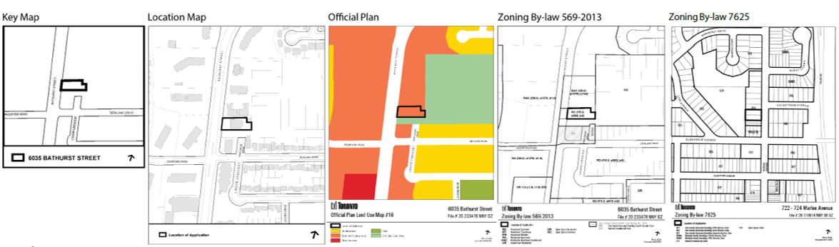
Leveraging FME’s capabilities of reading various file formats, City’s GIS, AutoCAD, Excel data, vector, and text elements were converged together, filtered and clipped to display the data on the map. The PDFPageFormatter transformer was an essential part in creating the map layout in addition to Safe Software’s MapTextLabeller plug-in to handle and organize the labeling of text on the map.
Besides, the project allowed the team to push the envelope on how FME can be used to produce cartographic elements, in PDF in this case, learning that will be of great benefit in future modernization projects.
THE VALUE WE PROVIDED
The automation project with FME enabled Valen’s team to become highly productive, turning hours of manual work of producing maps to generate the report graphics in just minutes. Now team members only need to run a quick visual quality check to validate the graphics and the maps are good to be sent to the client.
In addition to allowing the team to perform more value-added tasks, the speed with which the team can create reports also helps reduce lead times and increase the overall satisfaction of the city’s various stakeholders.
With the help of Consortech, the report mapping modernization project has greatly helped our organization not only by increasing productively within our own team, but it has opened up the doors of being able to automate other forms of work like automating report maps for heritage and exploring workflows for 3D terrain modelling.