The City of Henderson in Nevada, with a population of 310,000, is one of USA’s fastest growing cities offering tremendous economic development opportunities. Faced with the need to provide quality services to support this growth, the City devised CAD attribute standards that developers are expected to follow when submitting design drawings for construction approvals. The rationale for these new standards is to facilitate the integration of construction infrastructure into the enterprise GIS and Asset Management systems.
THE CHALLENGE
The City quickly discovered that integrating CAD data into a GIS database involved two additional steps: extracting attribution data from multiple PDF files and re-entering them manually. Understanding that this data could be made available in CAD files, the City`s team started looking for a partner that would help them develop an automated CAD to GIS conversion process to eliminate work duplication and potential errors, while procuring significant time saving.
HOW WE HELPED
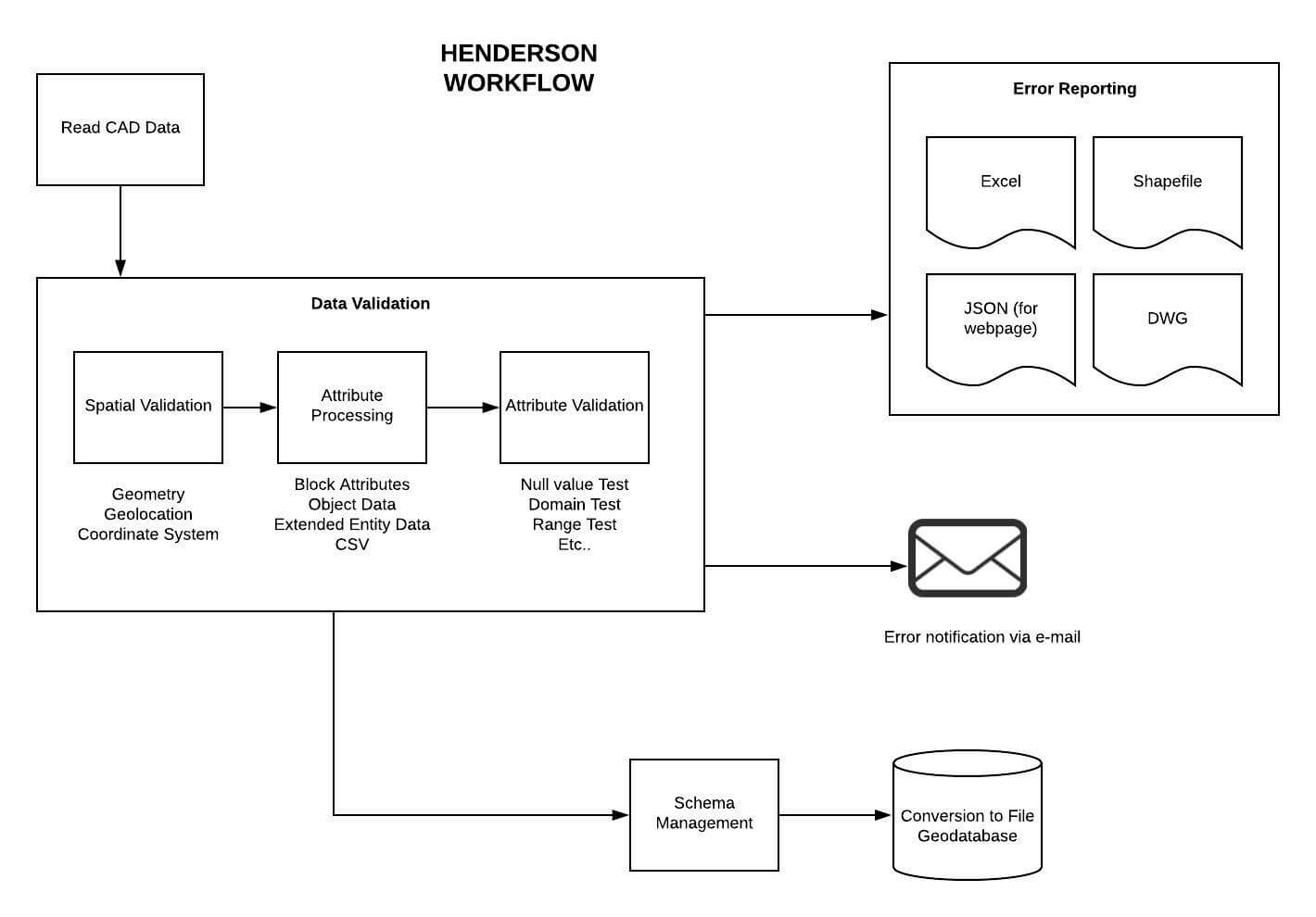
To fulfil the City’s need, we implemented an FME solution that would automatically execute CAD validation and conversion to GIS, with schema correction and reporting.
Leveraging our vast experience in CAD to GIS submission processes in municipalities, our certified FME professionals helped the City’s team in developing the new system, validating the data, implementing the conversion process and testing. Through working together, they also trained the city’s technical team on optimal techniques as well as best practices.
To further facilitate the process for developers, our team took on an additional challenge: offering them the flexibility to submit relevant information in multiple ways through ONE automated process! This involved creating separate Readers in the workbench and building checks upfront to eliminate failures resulting from user errors.
THE VALUE WE PROVIDED
Our contribution extended beyond FME development to assisting the client every step of the way. We guided the client, not just on technical aspects, but also on human and usability elements of the project. Drawing from our experience with CAD to GIS submission processes, we made them aware of the challenges involved in enforcing new standards and explained the nuances and techniques for bridging the gap between CAD and GIS data.
Our solution also had the advantage of being fully scalable since it could be easily deployed on a server or in the cloud, as required.
Above all, it’s simple to use! The City’s Web portal seamlessly launches the FME workspace with parameters required for the submission. In turn, users receive validation immediately on the quality of their submissions.
Net result: This revamped process reduced data integration time by as much as 75%, increasing the City’s efficiency in processing submissions. In addition, the client gained solid skills and a good understanding of FME, as it relates to their context.
Partnering with Consortech gave the City of Henderson the expanded knowledge and skillset to learn FME while completing this integral project. Consortech was very capable and flexible in meeting our requirements. The results exceeded our expectations.
Still struggling with CAD to GIS data conversion? We can help you!