With 21 years of FME experience under our belt, we’ve delivered successful projects to the governments of over a hundred municipalities large and small, with population sizes ranging from 5,000 to some million people. In most cases, regardless of how big the city or town was, FME was the top choice of GIS professionals to meet the conversion and automation needs of departments such as engineering, public works, land use and urban planning.
In recent years, FME has been used in better and more structured ways, its value as a versatile and robust data integration platform has earned it the respect of IT department heads, and the tool has found its way into a growing number of municipal departments and contexts. Read on for some examples of the ways FME can be used to boost efficiency in departments and situations that might not have occurred to you yet.
1. Balancing electoral districts for the clerk’s office / city council
The first example we’ll look at took place in an office rather used to doing things manually. Before adopting FME, it took about 10 person-days to manually process the information required to generate two or three electoral district balancing scenarios to be reviewed by city councillors.
It took the GIS analyst in a municipality (population: 100,000) all of one hour to automate this entire process. In addition to greatly reducing the work done behind the scenes, the main benefit of automation is the possibility of instantly generating multiple scenarios, supported by map-based visuals, during city council meetings. Great things can happen when efficiency meets transparency!
2. Managing non-resident voters for the clerk’s office
In the second case, we worked on the processing and sending of information to be communicated to non-resident voters during an election. Done manually, this is a generally long, menial job that takes enormous concentration, because it is a high-stakes process that has an enormous potential legal impact and leaves no room for error.
This GIS analyst for the same 100,000-person city above leveraged his FME experience to automate this process. It took him 20 hours to integrate all the applicable rules into an FME workspace, which saved the administration about 150 person-days and eliminated all possibility of human error.
3. Communicating with the public
The pandemic made it painfully obvious that the public and all stakeholders need to have access to information in almost real time. People need to know about the latest COVID-19 transmission numbers and what businesses and services are open or closed at any given time, so many communications departments have turned to GIS experts to share this information in the form of maps, reports and dashboards.
For instance, some created online forms with Survey123 that restaurant and store owners could fill in to add their information to maps organized around themes. In one specific case, a GIS specialist worked with FME and Survey123 to create the tasks required to efficiently compile and validate all information submitted and get it out to the public as soon as possible. It took him all of five hours of work.
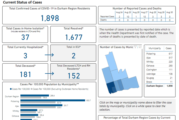
To share information about the spread of COVID-19, municipal organizations have leveraged the integration, web connection and pre-processing capacities of FME and FME Server. Case in point: Durham Region, which efficiently produced dashboards that integrate information from multiple sources and are regularly updated using fully automated processes.
In another case, health and educational facility administrators in a county in Missouri used to send out daily emails with the latest information contained in good old Excel files. It took several dozen person-hours to manually process and share this information every week. In a matter of about 10 hours, a GIS technician created an FME workspace, to be deployed on FME Server, that fully automated the task, with the added bonus of a feature that sent out reports confirming the process was running smoothly or alerts in the event of any problems or issues.
4. Managing incidents and prevention interventions for fire safety / public safety
By crossing demographic and socio-economic public data with internal data on incidents and interventions by public safety teams, analysts from this department can interpret trends and anticipate problem behaviours or situations. They can then set up targeted interventions to proactively prevent such situations.
More concretely, a GIS analyst for a city with 100,000 people put in under 50 hours of work to create an FME workspace to automate the loading, validation and pre-processing of data to be integrated into Esri maps and dashboards. Not only did this automation effort save fire safety specialists around 50 hours of repetitive work, but the most impressive advantage was a massive improvement in analysis quality. Before the analyst worked his magic, it was virtually impossible to spatially correlate and then analyze this data. Now, the department can plan their interventions with a much higher level of quality and accuracy.
In addition, FME can also be used, along with a specialized application (BeeOn in this case), to plan prevention initiatives in such a way as to optimize intervention circuits, provide field teams with real-time information, and allow them to update the information as their work progresses. And that’s not to mention that managers can have a visual representation of the real-time progress of operations and make any required changes.
5. Managing environmental liabilities
The environment is an increasingly important concern for the public, and municipal administrations have to meet new requirements from different levels of government in order to account for their environmental liabilities. This work is a joint effort by a variety of departments, such as finance (real estate), urban planning (right of use), engineering (environmental characterizations) and the registry office (real property rights), which must all constantly share information in real time.
FME’s integration power makes it possible to automate the centralization of this information, while keeping the connection with the independent systems that produced it. It also allows city officials to provide accurate, up-to-date information to regulatory bodies. Not only does this structure help municipal governments meet their legal obligations, but this centralized, better structured data can be quickly shared with city-appointed actuaries in order to support informed decision making that factors in any future financial and environmental impacts.
What are the best projects for you?
Of course, this is not an exhaustive list of all the ways FME can be used, or even our ultimate suggestions to municipal governments looking to boost organizational efficiency. We understand and appreciate that each city and town has its own specificities, and they have to assess their own needs before building their data integration and automation processes.
One thing is for certain, though: there is great potential for all municipal governments to improve their efficiency and provide their residents with better services if they tear down the silos between departments and harness the power of automation to eliminate repetitive manual tasks and, most importantly, to make better, informed decisions based on more thorough analysis.
We hope these ideas will inspire you to create your own projects that will benefit your organization.