
The year 2021 marks the end of a period of introspection for Consortech, during which we refined our vision around “geospatial performance.” This process has been so impactful that this vision has come to be our differentiator. Read on to learn more about geospatial performance, a valuable driver of visibility for GIS departments.
Geospatial performance is a way for a GIS department to position itself as a strategic contributor to a better managed and run organization. It supports decision making by disseminating all the right information to the right users at the right time, for the benefit of the management team, employees, the public and external stakeholders.
When the geomatics department is able to carve a place for itself as a strategic contributor, it initiates a virtuous cycle that leads to larger budgets and bigger teams. In turn, the team can respond to more requests from other departments and stakeholders in the organization.
In this post, we will look at the levers GIS managers can use to boost their geospatial performance. We won’t be going into an exhaustive description of each of them; we will focus instead on how to strike the right balance of effort and investment across all five levers.
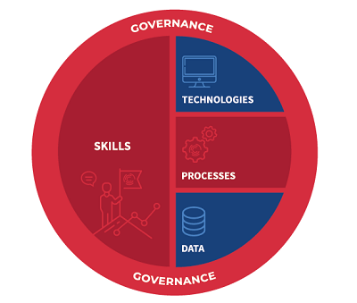
1. Data
We know you don’t need to be convinced of the importance of geospatial data as an input for decision support tools. But data acquisition can be a bit of a bottomless pit if you don’t have a strategy that factors in your clients’ needs, your level of maturity and your budget constraints.
Just like with any asset, the first step should be to take an inventory and properly catalogue your data before pursuing an acquisition strategy. The inventory will give you a clear idea of the strengths already at your disposal and the shortcomings that can be mitigated with reasonable efforts. Cataloguing makes it possible to narrow down the contexts in which your data can be used. For example, a five-metre accuracy range may be acceptable or it can render your data completely unusable, just as data that is two years old may be usable or completely obsolete.
Field data acquisition can be a great way to get accurate and up-to-date information, but the costs vary greatly depending on the options you choose, ranging from affordable, such as using drones to collect Lidar data, to very expensive, like sending out an army of technicians to conduct field surveys. Of course, it helps to fully understand your needs before making these decisions.
Other sources that often go underused, sometimes even ignored, are data produced by your partners and other levels of government (counties, regions, provincial, state, and federal). Open data is also an increasingly diverse and easily accessible source. We believe it is important for GIS leaders to position themselves as collaborators and contributors in order to provide and receive relevant data according to the needs and capacities of all stakeholders, for the benefit of the community.
2. Technology
GIS managers may be tempted to invest substantial amounts into their systems. After all, they offer so many possibilities, especially the products in the ArcGIS suite! But, unfortunately, we all work with limited budgets, so it’s always a good idea to step back and optimize your investments. To do that, you must put in the additional work to analyze your alternatives and the IT infrastructure you’ll need to adequately support your shiny new systems and functionalities.
Speaking of IT infrastructure requirements, we are witnessing a strong trend toward cloud computing, which can prove to be a headache for organizations that have already invested heavily in traditional systems or have considerable security constraints.
But there is opportunity in every threat: the accessibility of the cloud opens up new possibilities and can generate savings down the line. The usage-based pricing model of PaaS platforms and SaaS applications provides access to a multitude of new functionalities that would not have been possible with the old model, when you had to actually acquire all the technology tools you wanted to use.
3. Processes
We like to think of processes as the “computational logic” that breathes life into data by leveraging the capabilities and functionalities of systems. In the case of GIS specialists, processes range from, broadly speaking, data collection, processing and storage to dissemination and communication.
There is of course a wide variety of sub-processes in terms of data processing, such as validation, integration, correction, merging, analysis and enrichment. Some of these improve the quality of the data collected, while others serve to enrich and create value before the data are made available and disseminated. Security, an important factor, can also be covered by processes to take care of data anonymization, access rules, backup management, etc.
Understanding and optimizing the logic involved in data processing is central to our vision for geospatial performance. Processes can be understood through strategic thinking, and they can often be optimized by effectively defining and creating automations. Unless your GIS specialists are well versed in programming, we suggest you use FME technology. It streamlines data processing in the ArcGIS platform and also allows it to connect with external systems in order to break geomatics out of its silo.
4. GIS team skills
In a previous blog post, we talked about pandemic budget cuts, the impacts of the labour shortage on recruitment, and the fact that GIS teams are constantly asked to do more with less. In this context, we believe GIS managers should invest in their team’s skills by leveraging the many possibilities available to maintain and update their skillset. For instance, they can offer training to improve their team’s analytical skills and teach them how to use new tools and technologies.
Consortech’s approach to performance encourages GIS specialists to become more independent, so that certain tasks that are redundant or have low added value can be automated, freeing up time for more meaningful analysis work that can bring in greater returns for the organization. Importantly, this self-reliance also helps limit dependence on specialists from the IT department, who often have many other priorities.
It bears noting that training is not the only means available to maintain and update your team’s skills. Our customers have been increasingly relying on coaching and mentoring sessions, during which GIS specialists can learn new techniques and technologies by doing real-life work on their projects, working with real data, and using the best practices applicable to their own context.
5. Governance rules
Mature GIS departments that already enjoy a strategic position in their organization can also improve their geospatial performance by fine-tuning their mix of strategies using the four levers above.
These teams only stand to gain from implementing sound governance rules. As Esri Canada’s Allen Williams puts it, “Spatial data governance is an organizing framework that helps organizations establish strategies, objectives and policies for effectively managing and maintaining their data.” But for that to happen, the GIS department needs to have executive support.
Because our strategic work with our clients forces us to navigate in more ambiguous contexts, we propose a flexible method, which consists in setting up a framework and the rules required for the GIS department to grow in an organized fashion and at a sustainable pace, while leaving enough room to innovate and always keeping the organization’s rules and constraints in mind.
This framework and rules outline the roles and responsibilities of the stakeholders involved in the collection, processing, storage and dissemination of spatial data. They also cover the documentation of internal processes, standards and metrics—both quantitative and qualitative—of results from the geomatics department. We also set out rules for using a particular technology, such as FME and FME Server.
Geospatial performance: It’s all about balance
In our approach to geospatial performance, we believe it’s imperative to balance your efforts and allocate your budget between the levers you want to invest in. We also see that certain GIS specialists are a bit too willing to stay in their comfort zone when it comes to the data themselves or to the technology they use. It is tempting to always get more data and technology options when much of what geospatial data users actually need can be delivered through initiatives based on team skills and process optimization.
Consortech helps its clients strike the right balance across the levers that can have an impact on performance. We help decision makers put their data acquisition and technology options into perspective. But most of all, we place special focus on process optimization and skill development for GIS specialists, all while favouring malleable, adaptable governance rules and keeping organizational constraints in mind.
Ultimately, our mission is to set GIS leaders into a virtuous cycle, so that their department can create more value for the organization as a whole and get more visibility, along with the bigger budgets that come with it.